


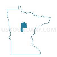
Torrey Twp. Voting District, Cass County, Minnesota
About
Outline

Summary
| Unique Area Identifier | 601413 |
| Name | Torrey Twp. Voting District |
| County | Cass County |
| State | Minnesota |
| Area (square miles) | 34.20 |
| Land Area (square miles) | 31.74 |
| Water Area (square miles) | 2.45 |
| % of Land Area | 92.83 |
| % of Water Area | 7.17 |
| Latitude of the Internal Point | 47.21376340 |
| Longtitude of the Internal Point | -93.86876990 |
Maps


Graphs
Select a template below for downloading or customizing gragh for Torrey Twp. Voting District, Cass County, Minnesota


Neighbors
Neighoring Voting District (by Name) Neighboring Voting District on the Map
- Morse Twp. Voting District, Itasca County, MN
- Salem Twp. Voting District, Cass County, MN
- Slater Twp. Voting District, Cass County, MN
- Sugar Lake Prec., Itasca County, MN
- Wahnena Voting District, Cass County, MN
- Wellers-Mccormick Prec., Itasca County, MN
- Willow River Voting District, Cass County, MN
Top 10 Neighboring County Subdivision (by Population) Neighboring County Subdivision on the Map
- Deer Lake UT, Itasca County, MN (3,495)
- Morse township, Itasca County, MN (615)
- Slater township, Cass County, MN (215)
- Wahnena UT, Cass County, MN (180)
- Torrey township, Cass County, MN (155)
- Salem township, Cass County, MN (95)
- East Cass UT, Cass County, MN (62)
Top 10 Neighboring Unified School District (by Population) Neighboring Unified School District on the Map
- Grand Rapids Public School District, MN (27,545)
- Deer River Public School District, MN (5,530)
- Northland Community Schools, MN (4,432)
Top 10 Neighboring State Legislative District Lower Chamber (by Population) Neighboring State Legislative District Lower Chamber on the Map
Top 10 Neighboring State Legislative District Upper Chamber (by Population) Neighboring State Legislative District Upper Chamber on the Map
Top 10 Neighboring 111th Congressional District (by Population) Neighboring 111th Congressional District on the Map
Top 10 Neighboring Census Tract (by Population) Neighboring Census Tract on the Map
- Census Tract 4807, Itasca County, MN (5,066)
- Census Tract 9400, Itasca County, MN (2,641)
- Census Tract 9601, Cass County, MN (2,062)